Pages

Sunday, April 21, 2013

Exploring Cockermouth Forest

There are so many mountains and trails in New England that we've planned to explore someday and haven't yet gotten to.  This hike hadn't been among that list, but I really glad we found it.  We have to thank a combination of John Compton, who did this hike last week and wrote a great blog post on it (HERE), and Clay for reading the blog post (which I hadn't gotten to yet) and suggesting that we repeat John's visit.  This hike includes Mt Crosby and Bald Knob, which are both really nice little peaks, as well as beautiful wooded trails through an old homestead (the Remick Place), over some ledges, along beautiful cascading streams and to a secluded pond.  Lots of great stuff!

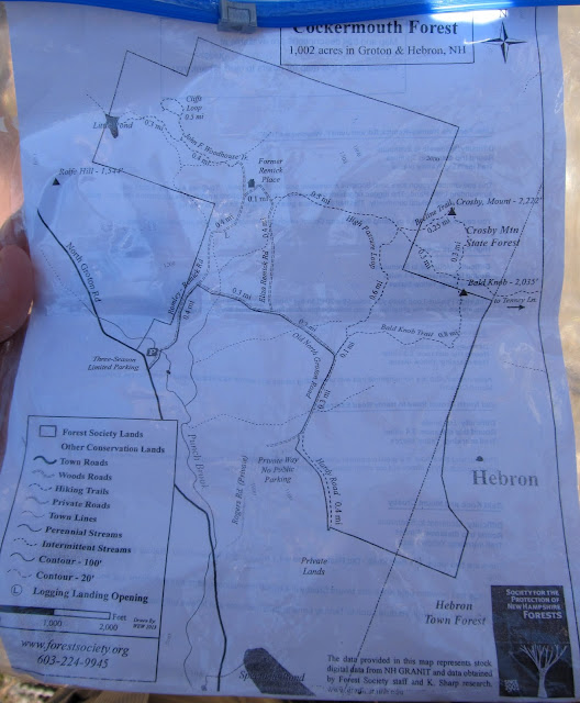
It was a beautiful day on Sunday - the perfect spring day to be in the mountains in New Hampshire - with just a trace of lingering snow, only slightly muddy trails and too chilly to be swarmed with bugs.  We arrived at the trailhead and found the small parking area full (there was still plenty of room to park along the road) and just one map left in the container at the new kiosk.  It's nice that they supply the maps since some of the trails have apparently just been recently built or restored and some of the navigation would have been a bit confusing without it.  There's an online version of the map at the Forest Society site HERE

We started out up Romley-Remick Rd and then cut over Old North Groton Rd to do the counterclockwise loop over Bald Knob and Mt Crosby.

New sign and trail maps


Starting up Romley-Remick Rd

The mile road walk and next mile up the Bald Knob Trail went quickly and we soon came out on the ledges of Bald Knob.  The views from here are beautiful, but are unfortunately dominated by a closeup of the wind farm that we saw from Mt Cube the day before.  When I read John's blog post I appreciated the reference to Don Quixote and the sight of the "hulking giants" that needed to be slain.  I have mixed feelings about these wind farms.  While they are a great source of clean energy they are also an intrusion on this beautiful landscape.  Much better than power lines though...

Sandra and Nat on the ledges of Bald Knob


Getting the close up view of the wind farm from Bald Knob ledges


A long line of "hulking giants"


Stark contrast


Clay enjoying the beautiful day


There are great views up here!

From Bald Knob it's only another few tenths walk through the small col and up to Mt Crosby.  The views from there are even better, but once again dominated by the wind turbines.  From here you get the full view of the ridge that had its top blasted off to create the level ground needed to install the wind farm.  Kinda' sad.

As we came out of the trees at the summit we found a couple of familiar faces already there - Steve Bjerklie and Polly.  They had come up from the opposite direction and the rest of the family arrived moments later.  It was great meeting you all out there!  You just never know who you're going to run into in the mountains.  We chatted for a while and then headed down to explore the rest of the area.

Mt Crosby ahead

Snow in the col


Quite a few Mowglis trail signs up here


Skating rink


Views from the Crosby ledges


Final approach to Crosby


Closer view of the "giants" and the blasted ridge from Crosby


After the steep descent down the Beeline Trail it's a nice walk over the Pasture Loop to the old Remick Place.  This is the area where things get a bit confusing in navigation.  Almost all the trails out here are well signed and blazed, but there are few junctions that require a bit of exploration to find the right connections.

Heading over the High Pasture Loop


Nearing the old Remick Place


Remick Place foundation - and lots of junk

We had decided that we should try to visit all of the "attractions" on the property, including the Ledges Loop and Little Pond - and we were glad we did.  Our first destination was up and over the loop which is a nice bit of scrambling and some short sections of open ledges with nice views to the surrounding area.

Glad we followed this sign!
 
On the Ledges Loop


Little Pond from Ledges Loop


Walking the spine

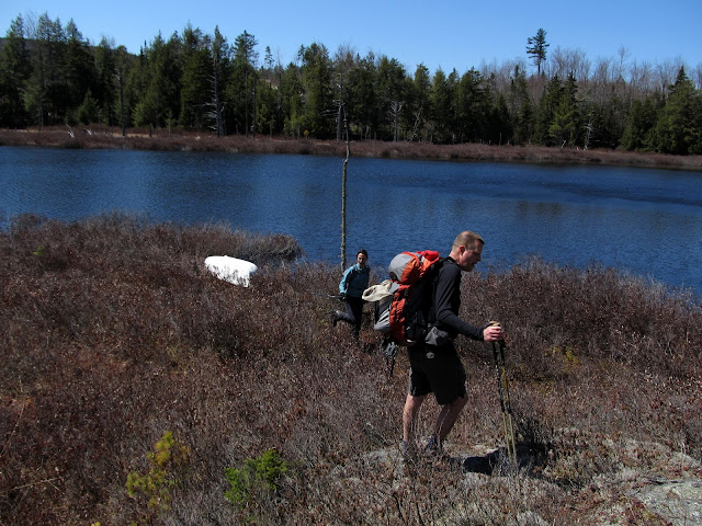
We got back to the loop junction and headed out the 0.3 spur to Little Pond.  This may have been one of the most worthwhile quarter miles that we've walked!  The trail follows a brook with a series of beautiful cascades that empties out of Little Pond - the gem of this walk.  This is such a beautiful spot and I'm sure that we'll return!  It would be particularly nice in the fall, with the foliage in the bog surrounding the pond lit up in autumn color.

At the outlet of Little Pond


Bogs around Little Pond


End of the line


Sandra had to check out the boat


This must be gorgeous in the fall!


Looking up to Lookout Ledges from Little Pond


Snow lining the far shore


We spent a long while soaking up the sun on the ledges around the pond.  We would have all been happy to just spend the whole afternoon here, but sadly Nat and I had to drive home to Rhode Island soon.  This had been a perfect way to end a great weekend.  Thanks again to John for providing the inspiration for this hike, to Clay for taking action on that inspiration and to Clay and Sandra for another great day out and an overall great weekend!

Many beautiful cascades


Heading out


Following the brook on the Woodhouse Trail


One of the trail maps provided at the new kiosk


The interactive map and GPS track are here:  http://www.gpsies.com/map.do?fileId=ypsogokyxligynlu


Saturday, April 20, 2013

Some Kodak Moments on Mt Cube

We spent a wonderful couple of days last weekend hanging out with our friends Clay and Sandra and exploring some new mountains in central NH.  First up for Saturday was Mt Cube.  This is one of the 52WAV hikes that I've been looking forward to for quite a while.  The weather forecast for Saturday had been iffy, and it was raining as we drove up through Mass.  By the time we hit the NH border the rain had stopped and in Bristol the sun was starting to peek through.  We had been prepared to hike in the drizzle if needed, but this was much nicer.

We got a pretty late start and weren't on the trail till near noon.  This wasn't going to be a long day and we had no place else to be though, so it really didn't matter.  We started out the hike with the 3+ mile road walk from the parking area on Baker Rd.  This is a nice walk that follows Jacob's Brook for much of the way.  There were some pretty muddy, wet sections - but hey, this is spring in NH...

Start of the muddy road walk


Avoiding the stream in the middle of the road


Nat and Sandra doing some rock hopping

With the road walk out of the way, we arrived at the trailhead for the Kodak Trail.  I had to do some research to find out the reason for the name and found it in a trip report from Steve Smith.  The Dartmouth Outing Club (who maintains these trails and others in the area) named it this because it climbs to the Eastman Ledges and, as Steve put it, provides numerous "Kodak moments".  It is indeed a scenic route.

After a few miles of road walk we're finally at the trail


Clay leading the way up the Kodak trail


Approaching Eastman Ledges


Smarts Mountain from Eastman Ledges


Zoom of Smarts

There is a nice long ledge walk along the Eastman Ledges with views to Smarts Mountain (on our list for the future) and much of the surrounding area.  After traversing the ledges we headed down into the col that leads to Mt Cube.

Looking down the ledges


Winter hasn't quite left yet


Heading down from the ledges toward Mt Cube

There hadn't been much snow to this point, but we found a little here.  What we found next was the result of the snow being gone.  There is one stream crossing on the Kodak trail at the bottom of the col that is presumably a simple rock hop in the summer.  Not so much today.  We couldn't see any of the normal stepping stones above the surface and the water was flowing fast at the regular crossing.  We walked a few hundred feet in each direction from the crossing and didn't really find a better option.  We wound up taking off our boots and wading it.  Nat, Sandra and Clay went at the crossing and I chose a spot about 20 yards upstream that seemed a bit easier.  The water was cold, but not awful and we made it across without a problem.  Onward...

This was where we had to cross.  No rock hopping today

On the way up to Cube summit we took the short (0.2mi) detour to the Hexacuba shelter.  It made a great place for a food break and it would have been a shame to miss seeing this unique structure (not to mention the adjoining Penta Privy).

Arriving at the Hexacuba shelter


Nat exploring Hexacuba


What better to go with Hexacuba...


A fine five sided privy

There's one more water crossing over a stream in a bit of a gorge after the shelter.  There's a bridge - if that's what you want to call a couple of split logs spanning the gap.  Tread cautiously...

The rest of the way up from there is more beautiful ledge walking.  I just love these spots!!


Half way across the "bridge"


Approaching Cube


Starting up


Sandra and Nat on the initial Cube ledges


Beautiful ledge walking

The clouds had move back in by the time we got to the summit, but the views were still beautiful.  We hung out for a while before reluctantly heading back down.

Smarts from Cube ledges


Lots more snow up here


Almost at the top


Wind farm from Cube summit


Mt Cardigan in the distance


Taking a break on the summit


Valley views


Looking up the AT to Cube summit

The first half of the way down was an icy monorail.  We held out for a while and tried to bare boot it, but finally gave in an put on our Microspikes which made the rest of the going easy.  We were back at the car at around 5pm - good time considering our considerable fooling around.  A great day on a mountain that we'll certainly be back to in the future.

The bridges home...


Icy monorail


The GPS track is here:  http://www.gpsies.com/map.do?fileId=arodtgzpyjeeuwvm
The start point and end point are actually the same.  The GPS just took a while to sync when we started.