Pages

Monday, July 22, 2013

A Morning Jaunt to Owl's Head (Cherry Mountain)

I've always wanted to say that I "took a jaunt to Owl's Head".  Well, actually I never really did, but it sounds cool.  The "other" Owl's Head was another time and another mind set.  This one is a different animal altogether...

We had two days left of our Seek the Peak trip and were hoping for two more hikes.  After the great day on the Baldpates on Sunday and skipping Mt Washington I had hoped for a another chance at a Presi day.  We weren't up for anything huge, and Caps Ridge up Jefferson had sounded perfect.  On Monday morning I checked the MWObs higher summits forecast and got a bit of bad news.  What was originally another clear, sunny day had now turned sour (much the reverse of Saturday) and the summits were now forecast to be in the clouds all day.  Caps Ridge would still be fun, but it seemed a shame to get up there just to be staring into a cloud.  Time for the second Plan B of the weekend (and this time we had one).

I'd been figuring that after getting a Presi day on Monday we could hit Cherry Mountain on our way home on Tuesday.  We hadn't been up there yet, and after catching the Presi views from Pondicherry last year I was anxious to check it out.  With possible storms in the afternoon on Monday this shortish hike made a great alternative for today.

We decided to take the west approach on the Cherry Mountain Trail from Rt 115.  This is the shortest (and most common) approach.  John Compton (the trail adopter for the east branch of the Cherry Mountain Trail and Martha's Mile) details the different approaches HERE.  Leaving the campground in the morning the weather was still nice - a bit warmer than Sunday but nowhere near the awful heat and humidity of the last week.  We got to the trailhead at about 9:30 and were the only car there.  We'd only see a few other people all day.

The beginning of the trail is a gentle climb on a soft path surrounded by many wildflowers.  If we hadn't had a view at the summits these would have been enough to make it a great hike.  I later found out from my "flower expert", Kevin Talbot, that the first sighting on the trail was probably the best - a rare Large Purple Fringed Orchid.  I didn't know what I was looking at at the time - just that it was beautiful.

Purple Fringed Orchid (apparently rare)


Heal-all


First Indian Pipes of the day (there were many)


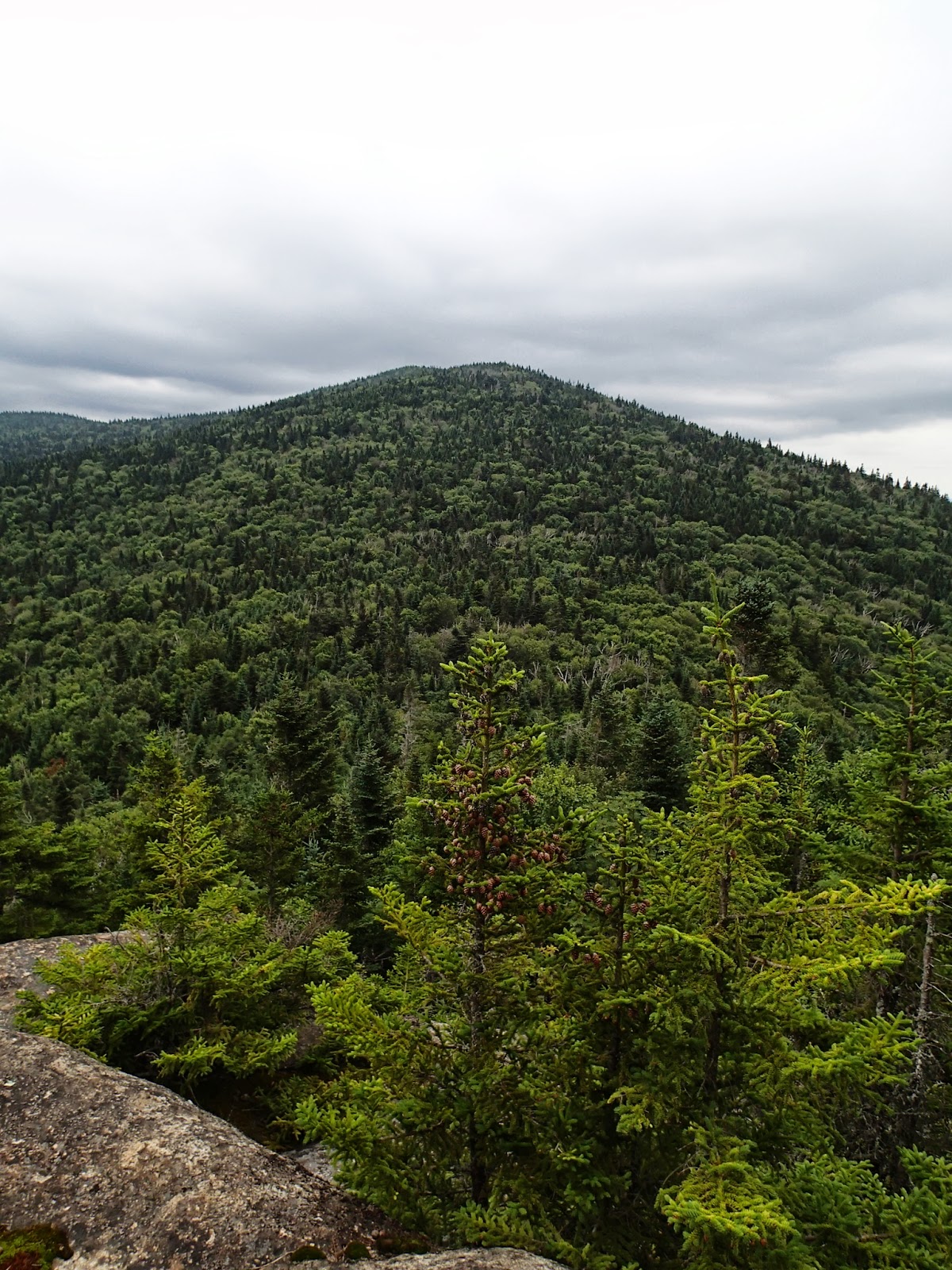
First views of the day (there were many of these too)


Shrooms


Shinleaf


Cherry Mountain trail


Wood Sorrel


The upper sections of the trail get steeper and rockier, but are still very nice.  While this is still an "easy" climb, it does gain 1900' in the 1.9 miles to Mt Martha (and more than 2500' overall with Owl's Head).  Making the turn at the junction with the Cherry Mountain Trail east branch the final 0.2 up to Mt Martha is on a wide path that leads to a summit with some pretty beautiful views.  It takes standing on the "viewing rock" to get the full picture (and it takes a day somewhat clearer than this one), but it's worth the effort.

Upper Cherry Mountain trail


At the crossroads


Presis disappearing into the clouds from Mt Martha


The Mt Martha "viewing rock"


White Yarrow


Old fire tower foundation on Mt Martha


Views from the back of Mt Martha

Leaving the summit of Mt Martha, the truly beautiful part of this hike begins.  Martha's Mile (actually 0.8 miles) is one of the most beautiful stretches of wooded trail that you're likely to find in the Whites (it's hard to compare anything in the woods to open ridges).  The only thing I can compare it to is the "enchanted forest" that we encountered on the Isolation Trail last summer.  Thank you John, for taking such obviously loving care of your charge.

And what a beautiful mile it is!


Start of Martha's Mile


Magical woodland


So much green

After the long stretch of soft paths and green surroundings there is the short, steep section up Owl's Head.  One could perhaps compare it to a mini-version of the approach to the other Owl's Head, but that would be most unfair.  There are one or two slightly tricky sections where one has to use the strategically placed trees to pull up over the steep rocks, but that's just part of the fun.  A few minutes of this and we arrived on the summit to a muted version of what are clearly amazing views.

Starting up Owl's Head


One of the Owl's Head challenges


First Owl's Head views


Mt Martha from Owl's Head


Presis in the clouds

When we got to the summit there was a large group of college kids there.  They were a bit noisy and enjoying their day, but we really didn't mind.  It's great to see young people out there enjoying these kinds of places.  We sat on the ledges and ate our lunch and they soon left and were replace by a woman and her canine companion - a three year old Lab that could have been a twin to the younger version of our Jake.  When he saw me watching him he strained at his leash and gave me that big doggie smile that Labs are so good at.  The woman smiled sheepishly at me and said "he really wants to say hello".  I replied "so do I", and so we did.  It makes me so happy to see a happy dog like this out on the trail.  I talked to him for a few minutes (and his "mom" as well) and then went back to finish my lunch.  They did some summit sitting together and then headed off before we got a chance to say goodbye.  Everything else that day was wonderful, but meeting them really made my day.

Summit sitters


North


Below the summit ledge


Nat loves the ledges


A little Alpine Hammock promo

The skies were starting to darken and we thought we might be in for some of the thunderstorms that were forecast for the afternoon, so we headed down.  On the way we noticed even more of the flora and fauna that we had missed on the way up.

Grand-daddy


Meadowsweet


Heading down


More of the many Indian Pipes


Heal-all

By the time we got back to the car the sky was clearing again.  We went back to the campground and spent a relaxing afternoon reading, listening to the birds and watching the clouds drift along the now blue sky.  We had clearly made the right choice for this day (particularly since it was pouring rain by the time we got up on Tuesday morning, washing out our final potential hike).  This was one of the nicest "small" hikes in recent memory, and one that we'll definitely repeat - hopefully on a crisp, clear fall (or perhaps spring) day with those incredible views on display.


Here's the interactive GPS track:  http://www.gpsies.com/map.do?fileId=ffdwprmbqsaxccno

And the overview of the route


Sunday, July 21, 2013

A Baldpates Gathering

If you've read my previous post you know the story of what happened to this year's Seek the Peak event.  The "weather delay" was unfortunate, but it was the right call.  It sadly meant that a number of people that were heading home on Saturday night or Sunday wouldn't be able to do their Mt Washington hike.  In our case we were staying until Tuesday, but had made plans months earlier to do a Sunday hike on the Baldpates if the weather was good.  As bad as the Saturday forecast had been, Sunday was equally good.  The warm front that had been hanging around and making things generally miserable had moved out overnight and was replaced by cool, crisp air and blue skies!  It was reminiscent of the day we hiked Mt Isolation after STP last year.  We'd hiked Mt Washington many times before, and although it would have been the perfect day for it, we couldn't pass up a day like this for the Baldpates.  Kevin and Judy had already decided to join us.  They'd done it for the first time last year and Judy had declared it to be her new favorite hike - high praise indeed.  Erich and Gloria were also going to be around for another day before their long drive home and decided to join us as well.  Although we've know Erich since our first Seek the Peak and have seen him every year since, including a chance meeting in Yosemite a few years ago, we still hadn't hiked together.  It was shaping up to be the perfect gathering.

I had made the drive from Gorham to Grafton Notch multiple times in the last two weeks for the car spots and pickup for our Mahoosucs backpack.  I was looking forward to returning and having a hike that I could remember a bit more fondly.  I wasn't going to be disappointed.  We got a leisurely 10:30 start, but we had no place to be and a beautiful day ahead.  We scoped out the many pies at the "pie lady" stand as we went by and promised to return to get desert for the evening meal on the way back.  With another day of white blazes ahead we were off...

Typical trail (at least when there weren't steps)


Never saw one of these before.  Very cool!

We took our time on the ascent of Baldpate West Peak. The trail was pretty nice with no real features of note in this part except the MANY stone steps up the final steep sections to the summit (and the AT benchmark along the way).  It's a nice enough trail and another testament to the experience we've had on all the trails in Maine so far.  When we got to West Peak things got a bit more interesting.

Reaching the summit of West Baldpate - East Peak ahead


Love these Maine views!


Mountain Cranberry


Trail down to the West Baldpate ledges


Sheep Laurel


The path awaits


We took a long lunch break on West Peak, enjoying the amazing views and anticipating the fun ahead.  The path up East Peak follows the line of ledges at the far left.  What a great path!

Lunch break


Kevin heading into the col

The walk across the col between the peaks is just gorgeous.  I could walk in places like this forever!

First ladder


Looking back to West Peak from the col


Bog bridges through the col.  What a beautiful section!


East Peak ahead

After crossing the col we were treated to a wonderful walk (and occasional scramble) up the East Peak ledges.  They're quite steep, but very manageable and the views along the way make you forget where you are.  These are the kinds of places in the mountains that I love the most.

Old Speck on the other side of Grafton Notch over West Baldpate


Going up!


Yes, the West Peak ledges are pretty steep


Another cool AT marker


Kevin coming up


The Mahoosucs over West Baldpate


Ledge views


Cairns leading into the sky


Mountain Sandwort

The summit plateau is no less spectacular than the ledges.  The actual summit of East Peak is on the opposite side and the walk across is simply gorgeous.  More of the 360 views open up the further across you get.

Approaching the summit plateau


Kevin and Old Speck


Summit plateau


Nat and Judy on the summit


On Baldpate East Peak summit with Old Speck in the distance


360 views!


Wind farm with Mt Blue beyond

We hung out on the summit for a long time.  Kevin, however, declared that it had not been long enough.  He decided that it would be easier to die up there and have the helicopter remove his body sometime later.  If you had to pick a place to die, this wouldn't be the worst choice...

Kevin, Erich and Gloria


Kevin waiting for the evac chopper


Nat and I on Baldpate East Peak.  Another NEHH...

Despite the prior caption, we have no aspiration toward the NEHH.  Repeat three times - "I will not start another list, I will not start...".  Oh, who knows - the lists haven't lead us any bad places so far.

All good things must come to an end and we finally headed back.  While I generally prefer loop hikes to out-and-backs, I didn't mind this one at all.  Lots of great spots to revisit the second time of the day (and the promise of a visit to Table Rock as well).

Heading back


West Peak, Old Speck and the Mahoosucs


Downward


Warning - kilts and ladders ahead!


Nat on the ladder


Back on West Peak

The walk back to West Peak was really nice.  The walk down the rest of the way was long.  Somehow those many stone steps from the way up had managed to double or triple on the way down.  Not sure how this happens.  About half way down the steps I almost made a serious mistake, slipping and taking a head first plunge that I somehow managed to catch with my arm, shin, hip and toe wedged under multiple downhill rocks without more than a couple of minor scrapes.  This serious lack of grace on my part is why I always take my time going downhill.  We made our way back to the Table Rock junction without further incident.  We now had a decision - 0.9 down to the car or an additional 0.7 out and back to Table Rock.  The views were rumored to be excellent.  The MATC sign at the junction sealed the deal.  During our prior Maine hikes we've been learning the MATC "view rating system".  Any view that is described with an expletive beginning with "E" (Excellent, Exceptional, Extraordinary) is NOT to be missed.

MANY stone steps


Another day of white blazes


We've learned to trust the MATC view rating system


Final climb onto Table Rock


The walk out to Table Rock involved regaining a bit of the elevation that we'd just lost and then a climb up a set of iron rungs on the final section to the ledge.  We emerged from the trees to find the view which was, well, Extraordinary!

View from Table Rock.  The MATC was right again!


Judy and I on Table Rock looking across Grafton Notch


Close to the edge?  Yes.


Me on Table Rock - too close to the edge!


Erich on Table Rock - WAY too close to the edge!!


Nat - dancing on the edge!  :-O

After enjoying the views and taking our turns hanging on the brink, we headed down and demonstrated our respective approaches to down-climbing a ledge with iron rungs.

Kevin's approach to the rungs


Judy's method (mine too)


Nat's method.  Show off!


Erich too.  Must be something about people in skirts - uh, kilts

The last mile to the car seemed longer than it was.  It had been an amazing day, but we were ready to get back for a much needed shower our swim and get together for dinner (and the soon-to-be-purchased pie).

The huge AT crossing symbol in Grafton Notch


Hike on...

Our stop at the pie lady stand was disappointing - everything was gone for day!  We stopped at the other stand back near Sunday River and found two remaining pies and a few whoopie pies left.  An apple pie and a whoopie were secured and we headed back to camp.  That night we got together for a great community meal and looked back on a most excellent day.  It wasn't Mt Washington, and we never even made it above 4000 feet, but it couldn't have been a much better gathering of friends in a more beautiful place.  Thanks Kevin, Judy, Erich and Gloria (and Nat of course) for making this a day to remember.


Here's the interactive GPS track:  http://www.gpsies.com/map.do?fileId=eruthttzxvcsluzm

And the map of the route.  Interesting that the GPS track seems to differ significantly from the map of the AT.  This is the third time in the last month or so where we've done an AT section hike with this result.  I really don't think the GPS is off.  In this particular case the path that we were on was definitely flatter and along the contour lines as the GPS track would indicate and not up and down over the "bump" shown on the map along the trail.  Is it possible that the AT map is out of date?  This is consistent on both the Open Cycle Map version shown here and and the USGS topo maps as well.