
Other than our visits to Acadia, our first time hiking in Maine was less than a year ago when we ventured just over the border to do Goose Eye, Carlo and Caribou during our Seek the Peak trip last July. We loved those first encounters with the mountains in western Maine and have equally loved all the others since. Baxter in August was amazing (and we can't wait to return this year). Our first visit to Stratton after Christmas introduced us to the mountains of the Carrabassett Valley and another simply beautiful place. The winter hikes were wonderful, but we knew that we needed to return in other seasons. Having tagged four here in winter there were six left (of the 4000 footers) to go. At the top of the list were the Bigelows. There is nothing that I love better than alpine summits and above treeline ridge walking. These promised lots of both, not to mention amazing 360 degree views on at least 4 summits along the ridge line if we did the entire range. Better yet, the Horns Pond campsite at the halfway point gave a perfect way to turn this into a two day backpack with plenty of time to enjoy those summits.
As always, the weather forecast had gone back and forth over the course of the week, but by the time Friday rolled around it was looking beautiful. We decided to take the afternoon off and beat the Boston traffic and other than one unexpected snafu at the beginning it was smooth sailing. By about 6pm we were heading up Rt 27 and planning our dinner at The Rack at Sugarloaf. Before we got there though, we ran into the first omen of a great weekend. Almost directly across from the entrance to Sugarloaf was the most amazing field of lupines that I've ever seen. The sun was just beginning to get lower in the sky and the light was beautiful. What a sight!

Lupines!


A few albinos

Bigelows over the Carrabassett River. Tomorrow...
After marveling over this amazing sight we headed over to The Rack for dinner. Unlike in ski season there was just about nobody there. A pound of wings (these must be from pterodactyls at 4 to the pound) and a BBQ pizza topped with brisket (different and delicious) were awesome! On the way out I noticed this sign posted alongside a bunch of others in the skier entrance area. I think it was trying to tell us something.
GSD = Get Shit Done!

Motivational message?
If the sign wasn't enough motivation and inspiration, this was. There was a passing thunderstorm while we were at dinner and as we drove from Sugarloaf to Stratton we were treated to this amazing view as the sun began to set

Amazing sunset after the storm

Driving the river of fire
We arrived at the Stratton Motel and got settled for the night. This is the motel and hiker hostel owned by Sue, the owner of the Maine Roadhouse that we stayed at in December. These are both great locations for hikers and in particular they cater to AT through hikers. In addition to the hiker hostel and rooms, Sue offers a shuttle service to surrounding trail heads and towns. We took advantage of this for our hike by having her shuttle us to the Round Barn campsite on the east end of Flagstaff Lake and leaving our car at the motel (which is a 1.5 mile road walk from the western Bigelow Range Trail trail head) - a perfect way to facilitate the backpack.

Mascots at the Stratton Motel
On Saturday morning we got up early and headed over to the Looney Moose Cafe. It's only about a mile from the motel and right next to the turn for the trail. The breakfast portions are HUGE and the food is great. Nat and I had the cranberry walnut pancakes and could only manage to eat one apiece. We got there a bit before they opened and took a walk on Rt 27 to kill some time. Even this was a beautiful place to be.

Coming to check us out

Guess we weren't interesting enough
We headed back to the motel and Sue picked us up and brought us to the trail head at Round Barn. It's about a 45 minute drive with more than half of it on really rough dirt road. Definitely not something to negotiate with a low clearance vehicle. By 9:30 we were on the trail. There wasn't a cloud in the sky, the temps were in the 60s and there was a breeze to keep the bugs at bay. It couldn't have been nicer.

Gearing up


Nat's ready!

On the trail
The beginning of the Safford Brook trail was dry (surprising considering all the recent rain) and nice to walk. Within a couple of easy miles we hit the junction with the AT. The rest of the day was white blazing from there.

AT junction

Hmmmm

First views appearing

Little Bigelow ridge

Lots of HUGE glacial erratics

Creative blazing

A little meadow
After a fairly steep climb we reached the ledges below the Old Man's Head - the first of many amazing viewpoints along the ridge.

Steep going

Kim catching the views below the Old Man's Head


The Old Man's Head

Taking it all in

Little Bigelow ridge

Goldthread lined the trails the entire way
After taking in the views from below, we headed up the rest of the steep ascent to the top of the Old Man's Head. There are a bunch of signs for viewpoints along the route. Some of them could be skipped. When you find one that says "Excellent Views", you need to pay attention. The sign below made us scratch our heads for a second before we got it. 2000 = the distance to go if you're southbound on the AT. Congratulations - you spent your first few weeks from Katahdin, traversing the 100 Mile Wilderness and northern Maine - just 2000 miles to go....

Only 2K to go if you're a SoBo

They really mean it!

Yes, this is an EXCELLENT view!


Nat on Old Man's Head ledges

Almost there

Final blazes to Avery Peak

At the top!

Wow

Thank you Myron for making this possible
It was simply stunning on the summit. It's hard to find a nicer place to be than an alpine summit on a sunny, breezy day (the breeze blowing the bugs away) with puffy clouds floating overhead and amazing views in every direction. We hung out for a long time up there.

Kim on the old tower foundation
\

Benchmark #1

Beautiful alpine summit! Summit marker ahead and West Peak beyond.

Benchmarks inside the tower foundation

Nat and Kim enjoying the views

Heading for the true summit

Nat and I on Avery Peak for NE67 #59

Ahead to West Peak

Back to the tower site

The ever present Sugarloaf
We finally gave in and headed off the summit and down into Avery col. The good news was that there were two more summits ahead for the day.

Heading for the next summit

Myron Avery tentsite in the col


Looking back to Avery Peak
It's only 0.7 between Avery and West peak, but it's a pretty good climb back up. We arrived to find more of the same amazing views.

Kim arriving on West Peak

Nat is close behind

Nat and I on Bigelow West Peak for NE67 #60

Kim and Nat on West Peak
We didn't hang out as long on West Peak as we were starting to see dark clouds gathering in the west. The forecast had said 0% chance of rain for the day, but we know how reliable that is. We still had a good bit to go before we could set up camp. The Horns still looked like they were a long way off.

Looking ahead to The Horns and darkening skies

One of the few cairns

Heading off West Peak

Sunlit forest

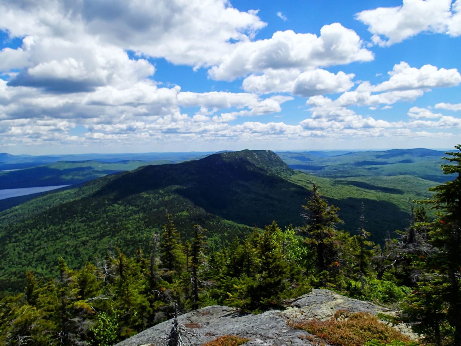
Looking back at the Bigelows from South Horn ledges
The push up to South Horn was tough. It hadn't been that many miles, but we were all tired and ready to make it to camp. We got more great views from the top here, including the view down to Horns Pond and our soon-to-be home for the night.

The Horns Pond from South Horn

Horns Pond with the lean-tos visible lower left (our home for the night)

Nat and I on South Horn

West Peak from South Horn
Kim pointed out that South Horn is a NEHH peak. Great, just what we need - another list. When we came off of South Horn we saw the sign for North Horn and another bald peak only a few tenths away. Perhaps we needed to go there? It might be on a list. We decided that it was on the "I don't care if it's on a list, I'm not freaking going there" list. We all felt satisfied by getting our checkmarks for walking right by the junction. Now just 0.3 down to the campsite.

North Horn from the ridge. Not today...
I've always said that the two miles down from HoJo's to Pinkham at the end of a Mt Washington hike is the longest 2 miles in the Whites. I've now decided that the hike from South Horn to Horns Pond is the longest 0.3 in Maine. At least it was this time. It felt like it went on forever. We were finally down, dropped our packs at one of the two shelters which had nobody in it, and headed down to cool off at the pond.

Cooling off at Horns Pond

Home sweet tent

Nice to be able to set up inside the shelter

The "squirrel can"
We came back and set up camp. The bugs were starting to get bad so we decided to pitch the tent body inside the shelter to have someplace to escape. We had planned to hang bear bags or use the bear box (if they had one) as usual, but apparently there are no bears up here. Instead of the typical campsite bear boxes, they have squirrel cans. Hmmm, these must be crafty little devils. We never saw any though. Not long after we got set up, the rain started. It was a quick moving storm and blew right through leaving clear, blue, cool skies behind (and chasing the bugs away again). After dinner we headed back down to to pond for sunset.

View up to South Horn from our tent

Sun setting over Horns Pond


Sliver of moon over the pines

Blueberry blossoms surrounding the pond


South Horn above our shelter

Clintonia (Blue Bead Lily)
We turned in early and all slept really well. We had planned to go out and check out the stars in the deep black Maine sky (slept through it) and get up early to check out the sunrise (slept through it). Sigh... The sky was blue and clear again in the morning, but the forecast was for rain by early afternoon. We got packed up pretty early and hit the trail. The air was a bit more humid and the breeze was gone. The black flies were out early and we were hoping to avoid them again. Little did we know...

Sugarloaf in early morning light

Sun breaking over South Horn


Black fly defense system
The trails between Horns Pond and Cranberry Peak are consistently rocky and often steep and "scrambly". Lots of ups and downs to taunt the day-two legs. We began with the short walk up to the ledges above Horns Pond (still on the AT). Had we known that the trail went up here we might have gone for sunset the night before. It was another beautiful spot.

Heading up from Horns Pond

Steep scrambling here

More huge erratics

The Horns over Horns Pond from the ledges

Wonder what this symbol means ???
It didn't take long before the black flies (and mosquitoes) got really bad. I usually don't have much problem with them, but even I couldn't escape them. Nat and Kim were getting chewed to pieces. They were trying everything they could think of to keep them at bay. Covering up wasn't a great option since it was now hot and humid too. Not much fun...

Lots of this today


Black fly ninja

More Goldthread
We got to Cranberry Peak Pond pretty quickly and hung out there as long as the bugs let us. This is really a beautiful spot and would be perfect on a cool fall day. When we got moving again we had a bit of confusion at the end of the pond. The trail appears to go straight ahead - and then disappears. I did a bit of unnecessary bushwhacking before Nat and Kim discovered that the trail turned left across the pond inlet on very rotten bog bridges that were almost not visible. We got across fine - I was just still cranky about the foray through the bushes - particularly after I discovered that I'd lost my sunglasses in there. Oh well.

The other pond on the route

Beautiful spot!

Cranberry Peak over Cranberry Peak Pond

Rhodora surrounds the pond

Spend some time bushwhacking before finding the obscure path
It's a substantial climb up to Cranberry Peak from the pond and we were all more than tired of being chewed by the flies. I got ahead and just kept going. I wanted to wait for Nat and Kim, but every time I stopped I got attacked. I wound up at the top about 10 minutes ahead and found a merciful breeze that kept them away - at least for a while. By the time Nat and Kim arrived the breeze had died and they were back in full force again. It was another really beautiful spot but we didn't hand around

Cranberry Peak

Looking back from Cranberry Peak

More 360* views

Kim's black fly defense

Nat enjoying the summit for a few breezy moments

Group shot

Time to go
From Cranberry Peak it's still 3.2 miles back to the trailhead plus another 1.5 on the road back to the car. I don't know what caused it, but my feet were giving me problems by this point and I really wasn't enjoying the walk. When I finished I discovered that I had blisters on three toes and I still don't know the cause. Need to fix this before the next hike though. Between the bugs, heat and foot issues the rest of the day wasn't much fun. I stopped a number of times to take pictures of the many wildflowers that lined the trail the whole way. It was a good diversion.

Labrador Tea

Still some Painted Trillium hanging on here

Starflower

More beautiful Rhodora

Bunchberry

Interloper on the Labrador Tea

Mountain cranberry

Another Tea invader

Red flowering lichen
About a mile from the trailhead we came upon this hiker registry box. Not sure why here and not at the trailhead. From here out the trail was very wet and muddy - just adding a bit more fun to the day. Kim had gone ahead of us, trying to escape the bugs. She made it to the trailhead almost 1/2 hour before us and was forced to find shelter. We knew this was a multi-function poncho / pack cover / shelter. Who knew it was also a bug house.

Registration box (over a mile from the trailhead). No idea what's up with Mickey

The final black fly defense

Heading out
My feet hurt like crazy, but I made the walk back to the motel in record time. I had my stuff in the car and was heading out to meet Nat and Kim when they walked into the parking lot. We were going to go down to the river to wash up, but just as we were getting ready, Sue pulled in. The fact that the motel is also a hiker hostel turned out to be a big benefit - for $5 each we were able to take showers before the 6 hour drive home! I think it was the best $5 I've ever spent. While I was waiting my turn, I talked to a couple of the SoBo through hikers that were staying at the hostel. They were three weeks in an enjoying the hike so far. Only another 2000 miles to go...
For all the bugs, sore feet, lost glasses and any other temporary aggravations I may have forgotten, this was still a fantastic weekend and one of the most beautiful hikes ever and I'm not the least bit sorry that we did it. Only 7 of the NE67 left to go for Nat and I, and 4 of them are back here in the Carrabassett Valley. Can't wait!
The interactive map and downloadable GPX of the route is here: http://www.gpsies.com/map.do?fileId=snmjdhbmtjwvkbtc There is a new feature that provides a Google Earth animated fly-over of the route (link below the map). Very cool!
A few more views here

Full Route


Route up Avery Peak. Viewpoints below and above Old Man's Head circled

Entire route from the east
Looks like a nice hike-
ReplyDeleteThanks John. One of the best ever! Hiking in Maine is just magical (but I don't need to tell you that). :)
DeleteGreat report and pics, Mark - what a beautiful place! The traverse between Avery and West Peaks reminds me a bit of the Franconia Ridge. I wondered if you had a similar impression, or did this hike maybe remind you of the Kinsmans? Had missed seeing your reports and was pleased to take this one in - one of the prettiest.
ReplyDeleteThanks Chris. A bit more like the Kinsmans than Franconia ridge - beautiful open alpine summits with pretty wooded cols in between. A truly incredible place.
DeleteIt's funny, I was hiking on Old Speck Saturday and all I could think of was how similar a day it was to the day I hiked the Bigelows last summer. And here's a TR from there! We looped the Bigelows and both Horns, but didn't do the rest of the ridge, and I'd love to some day. Your pictures only reinforce that. I think North Horn had the better views of the 2 horns personally, but they aren't that different from the main Bigelow peaks so you didn't miss much. And no longer on a major list, good news for you! Enjoy the rest of the Maine 4Ks, they are awesome.
ReplyDeleteThanks Matt - the coincidences go both ways. First, our original plan had been to do the Bigelow loop that you did (still as an overnight) since we didn't have a car spot option. Having Sue shuttle us to Round Barn and leaving the car in Stratton was a gift! This is such a beautiful traverse.
DeleteWe'll be back up in Stratton after Christmas again this year and I really want to do the west end of the ridge to Cranberry Peak again in winter (and the Bigelows too if that worked out). The rest of the Maine peaks will definitely be fun.
Looks like you've just got VT left for the NE67? We hit our last 4 there this winter (Abe, Ellen, Mansfield, Killington) and they were awesome winter peaks. I highly recommend them then!
As for the other coincidence - we're planning a 4 day Mahoosucs backpack in July (weather gods willing) starting with Old Speck and going south to Gorham. Can't wait for that one! Just need better luck with my feet than I had this weekend.
Hope to run into you on the trails someday!
Perhaps not a coincidence, Mark and Matt, but a connection - I climbed Killington from the ski lift base along the K-1 lift, for the most part this Saturday. No hint of the t-showers you had Sat night, Mark - crystal clear day with 90-miles views; Washington was at the limit of visibility, blinking on and off between Moosilauke and Franconia's formidable ridges. Views to the Greens, Taconics and Adirondacks were superb.
DeleteI prefer the aesthetic of a wilderness trail, though the continuous views of the Whites to the northeast and the emerging views of the northern Greens with elevation were very nice. Looking forward to some White adventures this weekend, hoping to enjoy similar alpine flower views to those you took in, Mark, two years ago on Monroe's south lawn - headed there and over Ike with a friend Saturday. Thanks again for your many inspiring and informative reports!
Beyond awesome report, Mark! Very impressive, from beginning to end!
ReplyDeleteJohn
Thanks John. Always fun for me to revisit the hike through words and pics. This one particularly so.
DeleteMark
These have been great postings, truly fine. I can smell the trees, rock, and wetness here in California and life is full.
ReplyDeleteThanks Terry. The last couple of weeks on the trail have been wonderful. Setting off today for another 4 day adventure that promises more of the same. Hope all is well in CA.
DeleteMark
Such amazing inspiration! I'll be heading up there this weekend and hoping for views half as good as you got! I'll be thinking of your photos on the long drive up.
ReplyDeleteThanks Allison. I hope you have a great hike (and that the bugs have let up a bit by now) - this is such a beautiful place! Look forward to reading your trip report next week.
DeleteMark